NuclearID
Guest
Hezbollah took responsibility for this attack right after the strike.
The impact in Majdal Shams appear to have occurred around 33°15'56"N 35°46'08"E as shown on Google Earth (image 1).
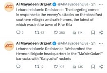
Sirens sounded in Majdal Shams at 18:18 local (image 2). Hezbollah then put out a series of statements claiming various attacks including a statement at 19:29 local, in which it claimed it targeted the “Hermon Brigade headquarters in Maale Golani Barracks with one Falaq missile” (base according to Hezbollah’s map located at 33°17'36"N 35°46'07"E) the distance between the base and the football field can be measured on Google Earth as around 1.91 miles away (image 3)
Last edited by a moderator:


 ️